Location and surrounding boroughs
Occupying an area of 106.97 sq km, the Borough of Llanera is located in the centre of Asturias and is bordered by the boroughs of Illas, Gijón and Corvera to the north, Gijón and Siero to the east, Oviedo to the south, and Illas and Las Regueras to the west.
Surface area, population and parishes
Llanera is composed of 11 parishes, which provide different physical and human sceneries depending on the economic activities carried out in each one.
There is no single centralised urban centre, but rather two important towns, Posada and Lugo, sharing the common features of being on important road and rail links and having a linear layout.
Next in size would be Villabona, a typical mining community, and the Soto de Llanera housing estate, representing the new urban model.
The borough’s rural communities, barely affected by the growth in the residential population, are varied, having been affected to a greater or lesser degree by home renovations and increased building activity. They range from small groups of cottages and farmsteads forming hamlets to dispersed settlements dotted with isolated farmhouses. Their situation on the bottom of valleys and gently sloping hillsides always leave the riverside meadows and the best land free for farming activities.
Parishes:
Ables, Arlós, Bonielles, Cayés, Ferroñes, Lugo, Pruvia, Rondiella, San Cucufate, Santa Cruz and Villardeveyo.
Relief, water resources and vegetation
About 95% of the borough is situated below 400 m in altitude. Only a few isolated ridges, such as Santofirme and El Águila rise above this elevation, with the highest point in Gorfolí Peak (617 m) on the municipal border with Illas. The River Nora, running along the borough’s southernmost limits, represents its lowest point (120 m).
There is a profuse network of short rivers and streams. To the south, small streams flow into the River Nora, while, to the north, the network flows into the sea.
The predominant vegetation is grassland and scrub replacing autochthonous forest, although there are still some wooded spots in the valleys and on the water courses. The banks of rivers and streams still preserve rows or galleries of alder, elm and willow.
Climate
The climate of Llanera may be defined as temperate, with an average annual temperature of no more than 20º, with annual average maximum and minimum temperatures varying only slightly.
The municipality is subject to between 900 and 1150 mm of rainfall per year, distributed fairly regularly.
Más información
The location and landscape of this territory have been crucial to its development.There is evidence of human habitation since the Lower and Middle Stone Ages, as evidenced by archaeological materials unearthed in the territory, with burial mounds being found in several areas: Ortal, the parish of Pruvia, and La Cobertoria.
The presence of villages dating from the Neolithic seems to gain strength, above all after the unearthing of important hill fort sites: La Coroña, in Ferroñes; Peña Menende, in Bonielles; El Canto de San Pedro, in Lugo; El Cueto, between Lugo and Villardeveyo, near Caravies; and Pico Cogolla, in Severies, in the parish of Rondiella, all keys to the actual location of Lucus Asturum, the main administrative centre of tramontane Asturias, constituting a crossroads, a place of transit and a settlement. Further excavations unearthed an altar dedicated to the Lares Viales (Roman deities who safeguarded the roads and travellers) in one of the walls of the Church of Santa Maria.
The feudal period was characterized by continuous interests on the part of the Bishopric of Oviedo in the territory of Llanera. Land administration, which at the time was usually associated with Las Regueras, was assigned by the Bishop of Oviedo to an encomendero or warden, generally of noble standing.
It is at this time that the borough’s most emblematic episode took place: the “wrongs and injustices” that they endured “at the hands of one of the wardens appointed by Don Guillén” (Bishop of Oviedo) resulted in open rebellion against the nobility on the part of residents of the borough, who were called the perxuraos or exconxuraos (perjurers or excommunicated) of Llanera.The importance of the Middle Ages is evident in the borough’s civil and religious heritage.
As a strategic site, it can claim to have been a mandatory place of transit for several trade routes.
The territory began to take on its present-day shape as a result of the incipient process of industrialization in the 19th century. The pits in Ferroñes were subsequently mined in the 1940s. The events of the first industrialization were mainly concentrated in the second half of the century, however. Thanks to the existing clay deposits, the Tejería Mecánica brickworks were established in Coruño, later becoming Cerámicas Guisasola.
The 1960s saw the start of the second process of industrialization in Llanera, one that has lent the borough some of the aspects that currently characterize its peculiar local evolution. The Silvota Industrial Estate was opened in 1963, followed by the opening of a second, privately-managed estate, Asipo. The open spaces of the latter served to establish Mercasturias –a wholesale market for foodstuffs–and the Technology Park as a centre for service providers.
The contrast with the mass concentration of the big city and its attendant anonymity, the speed of change and the lack of reference values symbolizing “progress” led many citizens to consider this area as an ideal place of residence, where natural riches and social structures never cease to amaze newcomers, constituting a source of pride for the locals.
The borough’s important historical and artistic heritage, the existence of a rich and varied cuisine, the holding of long-lasting festivals and fairs, good conditions for sports and the existence of particularly dynamic neighbourhoods and communities have enabled Llanera to occupy a privileged place on the territorial map of Asturias. Its infrastructure, facilities and amenities are available to all who visit the borough.
Gastronomy is another resource with a great potential from the point of view of supply, one of the features of the borough that produces the most satisfaction.
The gastronomic offering in the municipality is based on pork and market-garden produce. The most popular dishes include savoury stews such as fabada and pote asturiano, red meat and rice dishes, without forgetting game dishes and market-garden produce. Slow food dishes that safeguard the secrets of their flavour among stoves and recipes inherited from the past also play an important role. The star dessert would be rice pudding (a must dish in the “Disarmament” Gastro-event), along with filled crêpes and walnut-filled pastries called casadielles (so characteristic of the Lent Carnival menu).
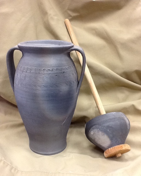
Municipal Pottery School – Villayo Pottery
Pottery courses are interesting for anyone who wants to gain a deeper understanding of the techniques, materials and processes of pottery making. Courses focus mainly on glazes, slips, pastes and kilns.
Activities
Recovery and conservation of Villayo pottery. Enquiries at the local branch of the Municipal Library Network (Address: C / Alejandro Mon)
Exhibitions:
-Feast of Los Exconxuraos (first weekend of July)
-San Isidro Market (in May)
-Single theme exhibitions