The Mansions Route
Though quite long, this route is an easy walk without steep slopes, as the borough of Llanera, located in the centre of Asturias, has a maximum elevation of only 600 m.
The path starts off in Posada de Llanera (the borough capital), next to the town hall, and runs along Quintana Street towards Santo Firme “peak”. Ramblers soon leave the asphalt well behind. The path running above the water deposits leads to the Santo Firme recreational area, offering views of Lugo de Llanera, La Morgal airfield and the Silvota and Asipo industrial estates.
Back on the narrow road, after passing through the small village of Mundín the route links up with the GR 100 or “Ruta de la Plata”, which runs between Gijón and Pajares mountain pass. The path bears left and then, after about 400 m, a track heads off to the left between two houses, going down a gentle slope before climbing uphill again to the old fluorspar settling tanks. The route borders these tanks to continue on towards the Villabona road.
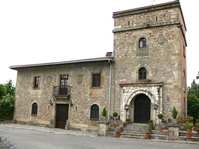
At this spot, you should a short detour of about 250 metres off the road to visit the Villabona mansion, dating from the 17th century, which is in a good state of repair. This mansion was listed as a Monument of Historic-Artistic Interest in 1978. The original building commenced with a small chapel, devoted to the Magi or Three Wise Men, which was built by the same architect who designed the ambulatory of Oviedo Cathedral and the city hall. It comprises a mansion with a single tower, including a chapel inside, built around a central courtyard. The west façade, which is now the main façade, consists of a central edifice between two towers. It has two coats of arms on the first floor and two loopholes topped with scallops flanking the door. The remains of Romanesque decoration from an old church have been found in the entranceway to the mansion grounds.
Retracing your steps, head back to the road that leads to a farmstead, from where a track leads downhill through a wood to Miranda Heights. Cross the main Oviedo to Aviles road and continue bordering the ridge, which overlooks Villardeveyo church. First built in the 11th century, this church still preserves a Pre-Romanesque latticework.
Head back to the main road, next to a hotel and large restaurant. From there, walk along the road for approximately 1 km to the junction where Ferroñes is signposted. The route now continues along a narrow, though not busy road and, after passing Ferroñes, head uphill towards the Arlós road. Cross this road and continue on through Panizales until reaching the village of Fresno, set among flat meadows. Here can be found the chapel of the same name and Peña Menende, where it is believed that there was a Roman settlement. Head downhill towards Fanes and then take the road to Los Campos (Avilés) before starting the climb up to Gorfolí “peak”, half a kilometre further on.
It is not a very steep climb and has easy access. You then come to a tableland with several aligned peaks, where you can either choose to reach the summit in a half hour or continue along the path to “Campo La Liebre” (The Hare’s Field).
Here again you have two choices, continue on or take a diversion to Bufarán, where you can enjoy a magnificent view of a large sector of the Bay of Biscay and several of its towns and villages, among which Aviles can be made out due to its proximity.
The route then descends a long track to Villayo to continue by road towards Santa Cruz, Carvajal and Vidriera. Shortly before reaching San Cucao, you will come to the Villanueva mansion (17th C.).
Passing through San Cucao, the route then heads for the Valdés tower (14th C.), a renovated mansion where riding lessons are available. Although the first constructions date from the second half of the 12th century, the different modifications the edifice underwent during the 19th and 20th centuries mean that the buildings we see today differ greatly with respect to their original appearance. Palatial in style, the mansion consists of a square, three-storey tower topped by crenelations. The entire building has thick walls with small mullioned windows and loopholes. The east side of the tower still preserves one of the original mullioned windows, boasting three coats of arms, which served as a model for the Neo-historicist bays.
The route continues through Guyame to then pass through the site where the Llanera Cattle Show Competition is held each year in mid-August, crossing the road once again before reaching the village of Severies.
Near here is the place where the “El Mazu” Mountaineering Group celebrates its anniversary every year on the last Sunday in May. A replica of the legendary Naranjo de Bulnes peak can be found on this spot.
The route finally descends towards Posada de Llanera, where the route ends.
As it is a long route, there are several points where you can follow just a section or split the route into two or three stages, but that is an individual choice.